山地是我國自然資源的富集區與涵養地、生物多樣性和人文多樣性中心,還是自然災害的多發(fā)區和全球變化的指示劑,廣袤的山地不僅為遙感研究提供廣闊的地理空間,也對實(shí)際應用提出了諸多科學(xué)和技術(shù)挑戰。山地崎嶇地形及濃縮的環(huán)境梯度顯著(zhù)影響了遙感成像過(guò)程,定量反演的建模在山區更加“病態(tài)”,且產(chǎn)品不確定性難以準確刻畫(huà),相關(guān)問(wèn)題已逐漸成為遙感學(xué)科的難點(diǎn)、熱點(diǎn)和焦點(diǎn)。近期成都山地所李?lèi)?ài)農研究員帶領(lǐng)團隊圍繞山地地表遙感輻射傳輸建模、關(guān)鍵地表參數遙感反演與驗證以及山區遙感綜合應用開(kāi)展山地遙感學(xué)科建設,并取得系列研究創(chuàng )新進(jìn)展。

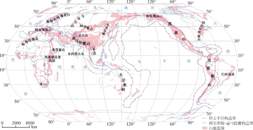
全球山地分布
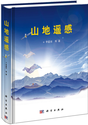
該團隊提出了協(xié)同幾何特征和特殊地理過(guò)程的山地遙感研究新范式,以此為主線(xiàn),結合國內外最新進(jìn)展,對山地遙感的相關(guān)研究做了階段總結,新近出版了《山地遙感》專(zhuān)著(zhù),書(shū)中不僅考慮山地“崎嶇地表”的幾何形態(tài),還結合山區實(shí)際研究對象的特殊時(shí)空格局和過(guò)程,從地理視角來(lái)闡述山地遙感理論、方法及其應用技術(shù),凸顯了學(xué)科特色。全書(shū)共12章,約90萬(wàn)字,內容兼顧了基礎性和技術(shù)性,是國內外首部圍繞山地復雜系統介紹遙感理論與實(shí)踐的學(xué)術(shù)著(zhù)作,為山地遙感學(xué)科建設鋪墊了新的基石。

《山地遙感》封面
山地遙感作為研究在山地這一特定環(huán)境中的遙感基本原理、方法及其應用的科學(xué)技術(shù),是遙感科學(xué)的重要組成部分,關(guān)注其山地特殊性。現階段,研究?jì)热葜饕ǎ弘姶挪ㄅc山地地表相互作用機理及建模理論,山地遙感影像自動(dòng)校正與時(shí)-空-譜歸一化處理方法,山地地表信息遙感反演與同化方法,山地遙感尺度效應與算法/產(chǎn)品驗證,山地遙感信息綜合應用等。
近期,相關(guān)研究成果發(fā)表在Remote Sensing of Environment、IEEE Transactions on Geoscience and Remote Sensing、Agricultural and Forest Meteorology等領(lǐng)域國際TOP期刊上。

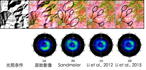
山區地形輻射校正模型結果對比

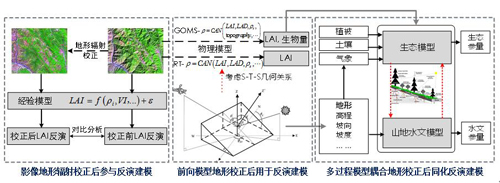
山地生態(tài)參量反演建模思路
最近,該研究團隊還在《遙感學(xué)報》“中國遙感二十年特刊”上應邀發(fā)表綜述,系統介紹了山地遙感主要研究進(jìn)展、發(fā)展機遇與挑戰。研究成果在《遙感技術(shù)與應用》已成功組織了兩期“山地遙感”專(zhuān)欄。
解讀《山地遙感》:http://mp.weixin.qq.com/s?__biz=MjM5MTIxNDMwOQ%3D%3D&idx=2&mid=2656080643&sn=d6c4602532bde1d0bf8c68d59d3aeaa6
《遙感學(xué)報》“中國遙感二十年特刊”之“山地遙感”:http://www.jors.cn/jrs/ch/reader/view_abstract.aspx?file_no=r16227&flag=1
《遙感技術(shù)與應用》山地遙感專(zhuān)欄鏈接1:http://www.rsta.ac.cn/CN/volumn/volumn_163.shtml
《遙感技術(shù)與應用》山地遙感專(zhuān)欄鏈接2:http://www.rsta.ac.cn/CN/volumn/volumn_165.shtml
新近代表性論文:
1) Yin Gaofei, Li Ainong*, Zhao Wei, Jin Huaan, Bian Jinhu, Wu Shengbiao. Modeling canopy reflectance over sloping terrain based on path length correction. IEEE Transactions on Geoscience and Remote Sensing, 2017, DOI: 10.1109/TGRS.2017.2694483. (IF = 3.360)
2) Bian Jinhu, Li Ainong*, Liu Qiannan, Huang Chengquan. Cloud and snow discrimination for CCD images of HJ-1A/B constellation based on spectral signature and spatio-temporal context. Remote Sensing, 2016, 8(1), 31. (IF = 3.036)
3) Li Ainong, Wang Qingfang, Bian Jinhu, Lei Guangbin. An improved physics-based model for topographic correction of Landsat TM images. Remote Sensing, 2015, 7(5): 6296-6319. (IF = 3.036)
4) Bian Jinhu, Li Ainong*, Wang Qingfang,Huang Chengquan. Development of dense time series 30-m image products from the Chinese HJ-1A/B constellation: A case study in Zoige plateau, China. Remote Sensing, 2015, 7(12): 16647-16671. (IF = 3.036)
5) Yin Gaofei, Li Ainong*, Jin Huaan, Zhao Wei, Bian Jinhu, Qu Yonghua, Zeng Yelu, Xu Baodong. Derivation of temporally continuous LAI reference maps through combining the LAINet observation system with CACAO. Agricultural and Forest Meteorology, 2017, 233: 209-221.(IF = 4.461)
6) Jin Huaan, Li Ainong*, Bian Jinhu, Nan Xi, Zhao Wei, Zhang Zhengjian, Yin Gaofei. Intercomparison and validation of MODIS and GLASS leaf area index (LAI) products over mountain areas: A case study in southwestern China. International Journal of Applied Earth Observation and Geoinformation, 2017, 55: 52-67. (IF = 3.798)
7) Zhao Wei, Li Ainong*, Jin Huaan, Zhang Zhengjian, Bian Jinhu, Yin Gaofei. Performance Evaluation of the Triangle-Based Empirical Soil Moisture Relationship Models Based on Landsat-5 TM Data and In Situ Measurements. IEEE Transactions on Geoscience and Remote Sensing, 2017, 55(5): 2632-2645. (IF = 3.360)
8) Jin Huaan, Li Ainong*, Wang Jindi*, Bo Yanchen. Improvement of spatially and temporally continuous crop leaf area index by integration of CERES-Maize model and MODIS data. European Journal of Agronomy, 2016, 78, 1-12. (IF = 3.186)
9) Zhao Wei, Li Ainong*, Nan Xi, Zhang Zhengjian, Lei Guangbin. Postearthquake Landslides Mapping From Landsat-8 Data for the 2015 Nepal Earthquake Using a Pixel-Based Change Detection Method. IEEE Journal of Selected Topics in Applied Earth Observations and Remote Sensing, 2017. (IF = 2.145)
10) Xia Haoming, Zhao Wei, Li Ainong*, Bian Jinhu, Zhang Zhengjian. Subpixel inundation mapping using Landsat-8 OLI and UAV data for a wetland region on the Zoige plateau, China. Remote Sensing, 2017, 9(1): 31. (IF =3.036)
11) Wang Jiyan, Li Ainong*, Bian Jinhu. Simulation of the grazing effects on grassland aboveground net primary production using DNDC model combined with time-series remote sensing data—A case study in Zoige plateau, China. Remote Sensing, 2016, 8(3), 168. (IF =3.036)
12) Lei Guangbin, Li Ainong*, Bian Jinhu, Zhang Zhengjian, Jin Huaan, Nan Xi, Zhao Wei, Wang Jiyan, Cao Xiaomin, Tan Jianbo, Liu Qiannan, Yu Huan, Yang Guangbin, Feng Wenlan. Land cover mapping in southwestern China using the HC-MMK approach. Remote Sensing, 2016, 8(4), 305. (IF =3.036)


